Background
Historically, many of Oregon’s open structured habitats, those dominated by grasses, forbs, and/or shrubs, were maintained by disturbance. Fire, floods, wind, storms, and salt spray have historically played a key role in shaping many of these native habitats. Natural disturbances shape Oregon’s landscapes by resetting plant succession, releasing nutrients, moving materials, creating new habitats, and maintaining native habitats, such as grasslands and savannas.
Altered fire regimes have changed vegetation patterns, affecting wildlife dependent on open landscapes. Fires have become statewide issues in the past century as Oregon’s population has grown, placing homes and communities closer to where these disturbances occur. Fires were suppressed to protect valuable timber and towns. The unintended consequences included increased tree density and fuel load of forests, which contributed to insect outbreaks, other forest health issues, and the risk of uncharacteristically severe fires.
Dams were constructed to protect towns from flooding, produce electricity, and provide irrigation for farms. The unintended consequences include impeded or blocked aquatic passage, as well as changes in hydrologic regimes that resulted in loss of floodplain function, loss of fish spawning and rearing areas, and degraded riparian habitats. These changes have all impacted Oregon’s fish and wildlife populations.
The recommended approach in the Conservation Strategy is to restore or mimic fire and flooding disturbance regimes to benefit fish and wildlife and reduce risks to people.
Altered Fire Regimes
Fire Suppression and Uncharacteristically Severe Wildfire
For thousands of years, fire has been one of the most important forces shaping Oregon’s landscapes, both forested and un-forested. Whether started by lightning or Native Americans, fire strongly influenced wildlife habitats by altering the structure, composition, and landscape pattern of native vegetation.
To understand the natural role of fire and how it should be managed, researchers have determined the “natural” (historical, pre-1850) fire regimes for many of Oregon’s habitats. Natural fire regimes are classified based on the historical range of fire frequency (e.g., the average number of years between fires) and fire severity prior to European settlement. Human intervention over the last hundred years has altered the historical fire regimes in many of Oregon’s landscapes. This has resulted in a cascade of unintended consequences for ecological health, wildlife populations, and people.
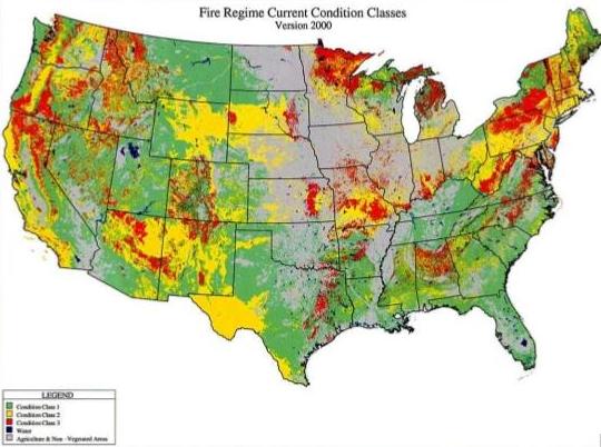
Fire regime condition classes are used to describe the amount of departure from natural (historical) fire regimes and were developed for all natural vegetation types. The following chart contains a simplified description of the fire regime condition classes and associated potential risks.
| Fire Regime Condition Class | Relationship to historical range of variability (e.g., vegetation characteristics, fuel composition, fire frequency, severity, pattern) | Potential risk of losing key ecosystem components (e.g., native species, soil, large trees) |
|---|---|---|
| Condition Class I | Within the natural (historical) range of variability | Low risk |
| Condition Class II | Moderate departure from the natural (historical) range of variability | Moderate risk |
| Condition Class III | High departure from the natural (historical) range of variability | High risk |
Forested Landscapes
In forested areas, vegetation changes following fire suppression have increased the likelihood of wildfires that are uncharacteristically large, severe, or both.
Nationally-developed maps that display coarse-scale fire regime condition classes show over one-third (39 percent) of Oregon’s 27.5 million acres of forestland in Condition Class III and another 45 percent in Condition Class II. The West Wide Wildfire Risk Assessment data add to the state information bank about fire regime condition classes.
The extent of change in natural fire regimes varies considerably among forest types. For the purpose of discussing fire, forests typically are grouped into three broad categories:
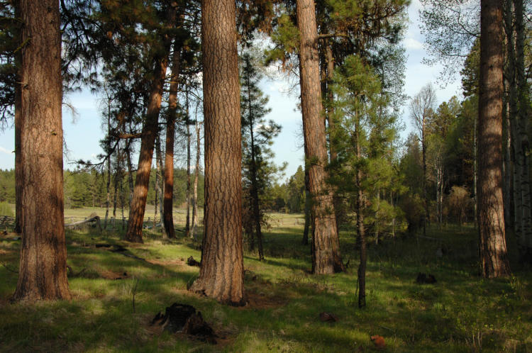
- Drier forests that are or were dominated by species like ponderosa pine, Douglas-fir, and larch historically tended to experience frequent fires (average intervals between fires of less than 25 years) that burned small trees and shrubs, but had limited effects on overstory trees with thick, fire-resistant bark. This pattern of frequent, low-severity fires is often referred to as an understory fire regime.
- Intermediate environments, such as mid-elevation areas supporting forests comprised of a variety of conifer species, had average fire return intervals ranging from around 25 to 100 years. The impact of fire on overstory trees could vary from minimal to severe (depending largely on weather and topography). This associated fire regime is often referred to as a mixed fire regime.
- Forests in moist, cold areas (or at least with cool summers, as in the Coast Range or high elevation mountains) tended to experience infrequent fires (average intervals of more than 100 years) that killed most or all of the dominant trees, leading to a stand-replacement fire regime.
The greatest extent of alteration to natural fire regimes has occurred in forests that historically had an understory fire regime. These forests are ponderosa pine and some mixed conifer forest types in the East Cascades, Blue Mountains, and eastern (interior) portion of the Klamath Mountains ecoregions. Human intervention, particularly fire suppression and past selective logging of large overstory trees, has shifted the historical fire regime from an understory fire regime with frequent, low-intensity fires to a stand-replacing fire regime with less frequent, high intensity fires.
Fire suppression (particularly on federal lands) eliminated the frequent, low-intensity fires that historically occurred in these forests. The elimination of frequent, low-intensity fires resulted in increased fuel loads in the form of surface fuels, shrubs, and smaller trees, and increased stand densities. Increased stand densities favored understory trees like Douglas-fir and grand fir. Dense understory trees served as “ladder fuels” that linked surface fuels and overstory fuels. Selective logging removed the larger, more fire-tolerant trees and opened the canopy, allowing more small, fire-sensitive trees to grow in the understory. The increase in fuel loads and stand densities made it more likely that when fire did occur, it would reach the forest canopy and spread as a crown fire. As a result of increased stand densities, larger trees became stressed due to competition with other vegetation for water and became more prone to insect infestation and disease.
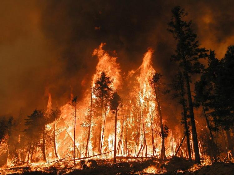
Because of their large size and intensity, uncharacteristic fires are more likely to cause adverse economic and environmental impacts. Fire has a negative economic impact on rural communities in Oregon whose economy and culture are based on forestry. Fire-fighting activities are a major expense for the state as a whole. In 2013, Oregon spent approximately $75 million on fire suppression efforts.
Uncharacteristically severe wildfires also pose higher risks to species and habitats because such fires can involve large areas and often result in complete mortality of overstory and understory vegetation (i.e., stand-replacing events). These stand-replacing fires can impact habitats, soils, and watersheds beyond their adaptive limits. Uncharacteristically severe wildfires impact aquatic habitats by removing riparian vegetation, which result in higher stream temperatures, decreased bank stability, and increased sedimentation in stream channels.
Many Oregon forests in fire regime Condition Class II or III contain Strategy Habitats or other important habitats for Strategy Species. Many of the Late Successional Reserves (LSRs) designated under the Northwest Forest Plan for management to preserve and produce late-successional forests are located in Condition Class II or III forests. These LSRs address the habitat needs of late-successional and old-growth forest-related species, such as the Northern Spotted Owl or Marbled Murrelet. Many riparian areas that provide habitat for fish species listed under the Endangered Species Act (ESA), including steelhead, Chinook salmon, coho salmon, and bull trout, are located in forests in Condition Class II or III. Many ponderosa pine forests in central and eastern Oregon are also located in Condition Class II or III.
Sagebrush, Grassland, Oak, and Aspen Habitats
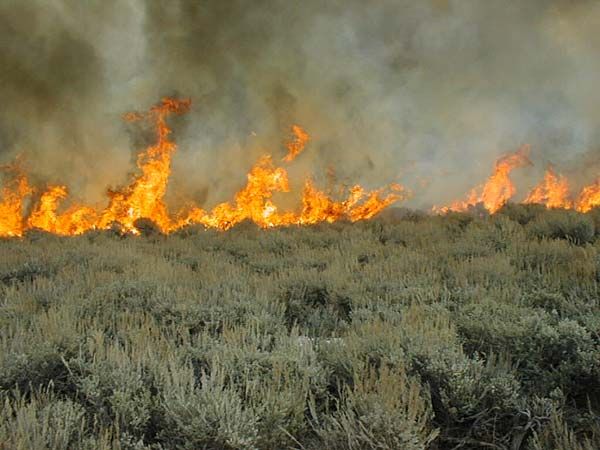
Fire historically maintained many sagebrush, grasslands, oak savannas, oak woodlands, and aspen woodlands by removing competing vegetation and stimulating regeneration of native fire-associated plants. Fire suppression has allowed shrubs and conifers to encroach into grasslands, oak woodlands, and oak savannas. Similarly, it has allowed western juniper to encroach into aspen woodlands, some riparian areas, and mountain big sagebrush habitats. Maintenance of these habitats over time will require the careful reintroduction of natural fire regimes using site-appropriate prescriptions, accounting for the area size and vegetation characteristics that affect resiliency and resistance to disturbance. In some areas, other techniques, such as mowing or controlled grazing, can be used to mimic the effects of fire.
Vegetation in sagebrush steppe ecosystems is adapted to arid conditions, and strongly influenced by fire and by drought. Drought, defined as two growing seasons with below average precipitation, has a pronounced impact on shrubs, grasses, and forbs. Drought can reduce sagebrush growth and impact grasses and insect populations, which can in turn result in less food for Greater Sage-Grouse and lower chick survival.
The issues of altered fire regimes and invasive species interact to create unnatural fire cycles in eastern Oregon, particularly in the Northern Basin and Range ecoregion. The introduction of invasive annuals, particularly cheatgrass and medusahead, can increase the frequency, intensity, and spread of fires. Breaking this cycle will require proactive management to prevent introduction of annual invasive species, minimizing the spread of cheatgrass, controlling wildfires in invasive-dominated areas, avoiding prescribed fire in cheatgrass-dominated areas, and conducting research on how to better restore areas dominated by invasive species. Habitats formerly dominated by sagebrush and native grasses that are now dominated by invasive annuals do not always meet the habitat needs of native wildlife, such as the Greater Sage-Grouse.
Altered Fire Regimes: Goals and Actions
Goal 1. Reduce uncharacteristically severe wildfire and restore fire or ecologically equivalent action in fire-dependent ecosystems to reestablish vegetative structure and species composition representative of a typical disturbance regime for forested and other systems.
Action 1.1. Use wildfire risk classification maps to identify local zones with greatest risk of uncharacteristically severe wildfire and prioritize for further action. Refer to restoration needs assessments based on departure from historical structure and composition to prioritize local zones for restoration action.
Coarse-scale fire condition maps have been developed for Oregon, but further work is needed to determine wildfire risk at finer scales. Specifically, refinement is needed to verify whether site-specific conditions are actually in Condition Class I, II, or III. These maps can then be used to prioritize which local sites need management actions to reduce risks. For example, the West Wide Wildfire Risk Assessment data add to the state information bank about fire regime condition classes. See the ODF’s Forest Resource Assessment for more information.
Setting priorities is essential, due to the magnitude of the areas requiring restoration and the limited resources allocated to their treatment. The risk of losing key ecosystem components is a factor that should be considered, with priority given to areas that currently are in fire regime Condition Class III (high risk of losing key ecosystem components) or Class II (moderate risk of losing key ecosystem components).
In identifying priorities for fuel reduction techniques, consideration should be given to both local site-specific conditions and the broader landscape context. Site-specific considerations should include identification of particular values at risk of loss from uncharacteristically severe wildfire, such as remnant large-diameter ponderosa pine. Larger-scale considerations should include factors such as the extent to which an area’s landscape context makes it highly valuable to wildlife (e.g., travel corridors, breeding locations) or more likely to be vulnerable to fire or contribute to fire spread. Similarly, proximity to human residences or high-value watersheds needs to be considered.
Action 1.2. Work with landowners and other partners in these zones to lower risk of wildfires while maintaining wildlife habitat values, and to choose the sites and landscapes for fuel reduction and forest restoration.
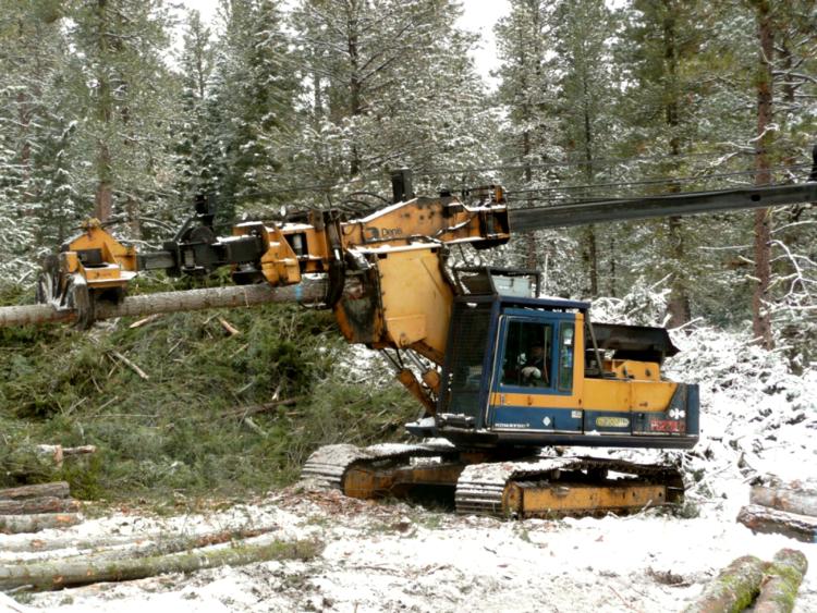
Site-by-site decisions must be made on the type and extent of fuel reduction treatments that will be conducted. Fuel reduction treatments must be balanced in relation to other ecological objectives. Many of Oregon’s habitats, including forests and high desert, are at risk for fire. Specifically, Oregon forests in fire regime Condition Class II or III contain Strategy Habitats that provide habitat for a number of Strategy Species, including species listed under the Endangered Species Act. If fuel reduction treatments are not undertaken, the long-term risk of losing key ecosystem components to uncharacteristic fire is increased. However, fuel reduction treatments can impact species and habitat by disturbing soil or eliminating key habitat components, such as canopy cover, hiding cover, snags, large woody debris, or large live trees. These impacts will vary depending on the extent, pattern, and level of fuel reduction treatments. Decisions on the fuel reduction treatments must balance the need to maintain these key ecosystem components with management needed to reduce risk of long-term damage to wildlife from wildfires.
In high priority zones, use active management techniques to reduce surface, understory, and crown fuels. Fuel reduction treatments typically involve mechanical treatments followed by the use of prescribed fire, if appropriate. The most common mechanical treatment is the removal of smaller trees by understory thinning or thinning from below, although other forms of thinning may be employed, as well as mowing and crushing to reduce shrubs and surface fuels. Maintenance treatments will be essential to supporting desired conditions and successional trajectories. Maintenance of areas in Condition Class I, especially in dry forest types, will also be important. In the absence of maintenance, areas currently in Condition Class I and II will continue to progress into Condition Class III.
Action 1.3. Seek and support cost-effective methods for reducing fuels, especially innovative approaches that increase the pace and scale of forest restoration and contribute to local economies.
In some areas, carefully removing understory biomass can restore habitats with historically open understories while reducing the risk of uncharacteristically severe wildfire by reducing fuel loads and removing ladder fuels. Developing markets for these small-diameter trees can create jobs, contribute to local economies, and help pay for restoration. The USFS’s Stewardship Contracting Program offers opportunities to implement and fund certain habitat restoration and management projects. Currently, there are several innovative projects to develop markets for small-diameter trees in Oregon.
Social acceptance for fuel management and other wildfire reduction efforts is likely to be greatest where various interests and values converge (for instance, in an accessible area of dry forest types where restoration would protect residences, restore or conserve habitats of concern, and provide a commercially valuable timber by-product that could be processed in a local mill). Given the great disparity between the extent of areas needing treatment and the limited resources to accomplish the necessary treatments, careful consideration of factors related to social acceptance, as well as fire risk and other ecological elements, should help identify areas where projects can both provide substantial benefits and have a high likelihood of being successfully implemented. Thus, collaborative approaches to prioritize and plan fuel reduction efforts must include diverse public interests. Collaboration between federal land management agencies and a variety of organizations, groups, and agencies is required for projects undertaken through the Healthy Forest Restoration Act and Stewardship Contracting. Furthermore, the monitoring of fuel reduction techniques discussed above is essential for both refining techniques and building trust and confidence among stakeholders.
Community-based forest health collaboratives have been emerging across Oregon over the last 20 years. The emergence of these collaborative partnerships has been, in large part, to provide review and recommendations for federal forest management activities occurring near their communities. Starting with a handful of pioneering local partnership efforts in the 1990s, the number of community-based collaboratives now exceeds 20. As of 2012, there is at least one community-based collaborative group working with each of the 11 National Forests that are wholly, or in part, included within the state’s boundaries.
These groups identify local forest health priorities through a community-based process, develop landscape-scale forest restoration plans, and develop agreement on active management and restoration approaches. Collaboratives bring together representatives from federal, state, and local governments, conservationists, timber interests, tribes, and other local groups to develop a clearly defined vision and strategic goals for cooperative restoration. The work of local forest collaborative partnerships has been shown to be an important means for establishing local support and agreement for forest restoration treatments, thereby increasing the potential for an acceleration in the pace and scale of forest restoration.
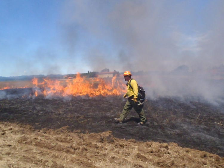
Action 1.4. Using site-appropriate prescriptions, carefully reintroduce natural fire regimes as part of an overall wildfire risk reduction and habitat restoration program in locations where conflicts, such as smoke and safety concerns, can be minimized.
Forested Landscapes
Because of high fuel loads in many areas, the most typical scenario will involve mechanical treatments followed by fire. Prescribed fire typically will involve intentional human ignitions, but strategic use of lightning-caused fires can also be beneficial under well-defined conditions. A program of active fire suppression will continue to be a necessary part of an overall fire-management strategy to protect local communities and private property.
Management actions, such as active thinning and prescribed burning, in at-risk green stands should eventually reduce the amount of effort and funding needed for fire suppression in those areas. As discussed previously, active maintenance may be needed in some areas. However, the overall goal should be the restoration of conditions where natural fire can perform its historical ecological role across more of the landscape and where compatible with existing land uses. Planning for wildfire risk reduction and habitat restoration should evaluate if it would be feasible, ecologically appropriate, and socially desirable to allow the historical fire regime to return once high fuel loads are addressed.
Unforested Landscapes
Prescribed fire can be a useful tool when tailored to local conditions. However, prescribed fire is not necessarily suitable for all situations. In the Northern Basin and Range and Blue Mountains ecoregions, low productivity communities are extremely slow to recover from prescribed fire and other disturbances. For example, low sagebrush communities have poor, shallow soils and are slow (150-300 years) to recover from significant soil disturbance or fire. Wildfires and prescribed fire can both increase dominance of invasive plants, dependent on the site conditions.
In the Klamath Mountains and Willamette Valley ecoregions, prescribed fire poses challenges, such as conflicts with surrounding land use, smoke management and air quality, and public safety. In the Coast Range ecoregion, prescribed fire is difficult due to high precipitation and wet conditions. When conditions are dry enough to use prescribed fire in coastal grasslands, there are usually concerns with risk to surrounding forests.
To address these issues, carefully evaluate individual sites to determine if prescribed fire is appropriate. Be particularly cautious in low productivity sites where recovery times are prolonged or in sites with invasive annual grasses. If determined to be ecologically beneficial, reintroduce natural fire regimes using site-appropriate prescriptions and considering conflicts, such as smoke and safety concerns. If prescribed fire is not appropriate or feasible, consider alternative methods that mimic the effects of fire (see Action 1.5 below).
Action 1.5. Use site-appropriate tools, such as mowing, brush removal, tree cutting, and controlled grazing to mimic effects of fire in fire-dependent habitats.
Use multiple site-appropriate tools to maintain open structure habitats. These may include mowing, controlled grazing, hand-removal of encroaching shrubs and trees, or thinning. For all tools, minimize ground disturbance and impacts to native species. Use mechanical treatment methods (e.g., chipping, cutting for firewood) to control encroaching conifers. In aspen habitats, reintroducing a disturbance regime may be necessary to reinvigorate aspen reproduction after mechanical removal of conifers. In areas where western junipers are expanding into sagebrush habitats, maintain older juniper trees, which are very important for wildlife.
Action 1.6. Develop tools that evaluate trade-offs between short-term loss of wildlife habitat values and long-term damage to habitat from wildfires and
Action 1.7. Evaluate effects of forest management practices that reduce wildfire risk to wildlife habitat values.
Efforts to reduce wildfire risk and restore habitats need to occur within an adaptive management framework in which actions are monitored and modified in response to results and changing conditions.
In some cases, wildlife habitat elements, such as hiding cover and snags, will be reduced by fuel reduction activities. However, not taking any action could result in complete habitat loss through severe wildfire. Thus, analytical tools are needed to evaluate and compare the short-term risk of fuel reduction treatments to species and habitats against the long-term risk to species and habitats posed by uncharacteristically severe wildfire. Such tools would assist landowners and land managers in determining appropriate actions for individual sites.
Fuel reduction techniques need to be monitored to determine the short-term impacts of fuel reduction techniques on species and habitat, and the long-term effectiveness of fuel reduction techniques in reducing the risk of uncharacteristic fire. Furthermore, research is needed to better understand the effects of historical fire regimes, severe wildfire, and fire suppression on wildlife. Also, historical disturbance regimes are not well-understood for all habitat types, so research is needed to determine the historical frequency and severity of disturbance that maintained Strategy Habitats. Formulate management approaches, including use of prescribed fire, accordingly.
Action 1.8. Use herbicides to minimize colonization of invasive winter annuals after wildfire in shrub-steppe communities.
After catastrophic wildfires in sagebrush-dominated communities in drier parts of the state, like the Northern Basin and Range ecoregion, herbicides can be used to kill invasive winter annuals, such as cheatgrass and medusahead, so they do not dominate the post-fire landscape. This can greatly improve the ability of native grasses and shrubs to re-colonize and establish.
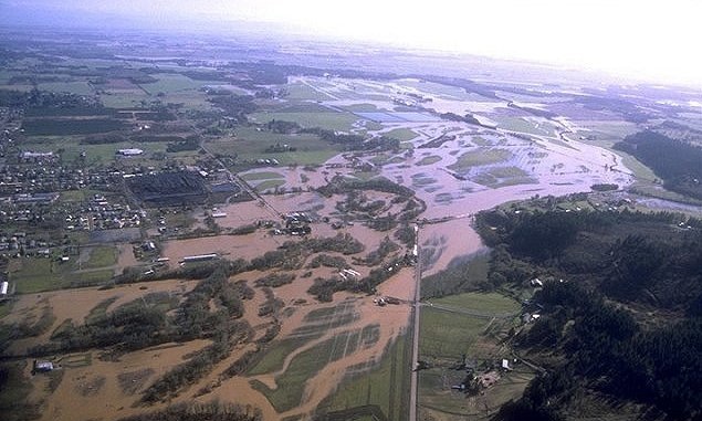
Altered Floodplain Function
From time to time, Oregon’s waterways, filled by rains and snowmelt, overflow their banks and spread across the landscape. Minor floods occur relatively frequently and on most Oregon streams at one time or another. Many streams flood once or more each season. Flooding occurs under different circumstances on the west side of the Cascades than on the east side. Floods on rivers in eastern Oregon are more often the result of spring snowmelt. The central and eastern areas of the state are also subject to summer thunderstorms that drop large amounts of rain in short periods, overwhelming the soil’s capacity to absorb the moisture and river systems to transport it, resulting in flash floods. In western Oregon, winter storms and spring rain-on-snow events contribute to seasonal flooding.
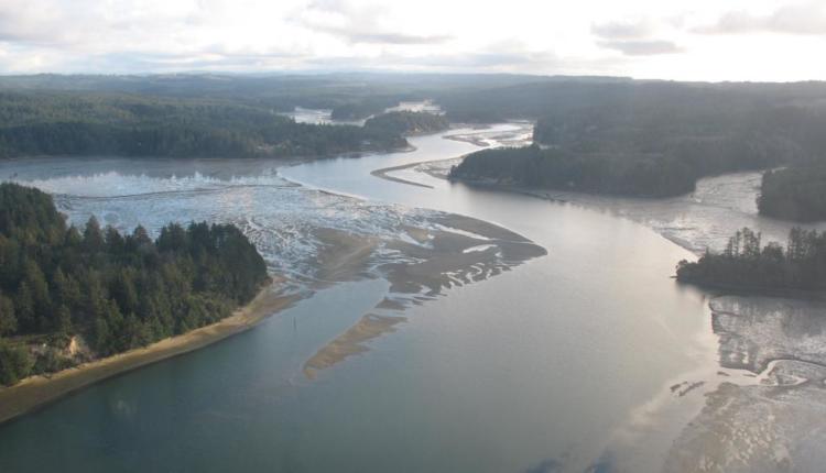
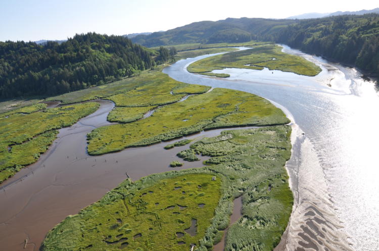
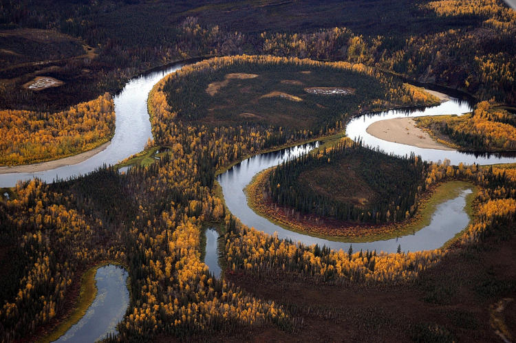
The area of land adjacent to the river that absorbs overflow during floods is the river’s floodplain. Rivers often carve new courses during floods. Over time, rivers gradually move across the landscape creating oxbows and excavating new channels and alcoves. This makes naturally flowing rivers good habitat for aquatic species and floodplains fertile habitat for terrestrial species.
History of Modification to Oregon’s River Systems: Dams and Channelization
Oregon’s first dams were built in the late 1800s to supply electricity to cities. Many “splash dams” were built to transport logs from forest to mill, but they did so much damage to streams they were outlawed in 1958. Significant dam building took place between the turn of the last century and the 1960s. Initially, the federal government built dams to provide irrigation water to farmers. The first of these projects in Oregon (under the 1902 Reclamation Act and managed by the Bureau of Reclamation) was the Klamath Project, a complex of dams and canals that drained extensive wetlands and diverted lake water to irrigate 225,000 acres of former rangeland. By 1940, over 70 percent of Oregon’s current water storage capacity was in place behind eight Bureau of Reclamation dams. While many of these dams may provide a variety of services, flood prevention was not their primary purpose.
As human settlements grew along rivers, buildings, towns, and farms were subject to damage by floods as well as erosion from meandering river systems. Development of communities in floodplains increased the demand placed on these ecological systems. Dams increasingly became important for flood control. The Flood Control Act of 1936 declared that flood prevention was in the public interest and thus was a responsibility of the federal government. The U.S. Army Corps of Engineers currently operates 20 dams in Oregon, 11 of them west of the Cascades. Those constructed on the Columbia River (i.e., Bonneville, The Dalles, and McNary) were built to generate electricity, rather than provide storage. Today, the greater percentage of dams across the state are operated by cities, local districts, or individual landowners for a variety of purposes, including flood control. There are 1,100 dams in Oregon that are considered to be relatively large (at least 25 feet high).
In addition to dams, rivers have been modified in a number of other ways. Rivers have been dredged and deepened to improve their use for transportation, flood control, and irrigation needs, as well as to increase the area available for agriculture. Large stone riprap, levees, and deflectors harden and stabilize banks and redirect river flow to prevent erosion and channel movement. These structures constrain rivers to a single course, disconnecting them from their floodplains.
Effects on River Dynamics, Floodplain Function, and Fish and Wildlife Habitats
While dams and revetments provide valuable services to human communities, they alter river dynamics that affect aquatic and terrestrial communities in significant ways. Floods on wild rivers renew floodplain soils and aquatic habitat, and are part of the normal pattern of disturbances that shape Oregon ecosystems.
The loss of a river or a stream’s connection to its floodplain reduces its ability to absorb floodwaters. When small streams and creeks reach flood stage and overflow onto adjacent lands, the pulse of floodwater slows before reaching larger rivers. The speed and severity of modern floods is increasing with the loss of this floodplain “sponge effect”. In developed areas, modifications have been made throughout river and stream systems. Paved surfaces significantly limit infiltration into the ground and instead concentrate stormwater into pipes and directly into streams. In rural areas, agricultural ditches move water off the land quickly. Across Oregon, many rivers have been channelized. As a result, floodwaters barrel downstream, overwhelming the larger rivers instead of spreading across the landscape and gradually infiltrating or evaporating.
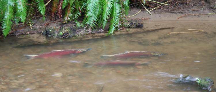
One of the important functions of flooding is to move gravel from uplands to bottomlands. Clean gravel is an essential streambed surface for healthy salmon spawning beds. Side channels created by freshly-deposited gravel bars provide sheltered settings outside the main river current where young fish and other small aquatic creatures can rest or feed. When it flows through gravel, water gets cooler and changes chemistry, improving conditions for coldwater anadromous species. Dams trap gravel and silt, and constrain major floods that would normally move gravel downstream.
Channelization can contribute to greater streambank scouring and erosion as loss of stream complexity (e.g., bends, pools, eddies) destabilizes banks and interferes with gravel transport and deposition. Within a floodplain, modified flow limits channel migration, which in turn limits the creation of off-channel habitat, such as oxbow lakes, backwaters, and sloughs that provide important habitat for Strategy Species such as the Oregon chub. Since natural river channels are maintained by a dynamic equilibrium between erosion and deposition of gravel and silt, water moving without silt or through straightened channels can cause riverbed and riverbank erosion.
In natural systems, large floods send logs tumbling into mountain streams and topple trees along riverbanks. The force of floodwater moves submerged logs into new locations. These actions rearrange the river habitat, flushing out sediment and setting up new complex structures necessary for healthy aquatic habitat. Dams temper the force of floodwaters, diminishing the power of streams and rivers to move large wood, thus depriving streams of new structure that is important for fish habitat. Channelization removes the complexity of existing stream structure which straightens and speeds flows, thereby depriving streams of potential locations for large wood debris recruitment and retention.
Water temperature cycles are altered by impounding water behind dams, with resulting disruption of temperature-dependent life cycles of anadromous fish and their food sources. Flowing water in streams is full of nutrients and oxygen. Riparian vegetation provides important shade to keep water cool. Water held behind dams warms in the summer sun. The surface temperatures rise while cold water sinks and suspended material settles to the bottom. Phytoplankton, single-celled plants that make up the base of the food chain, proliferate at the top, releasing oxygen. When they die, they sink to the bottom where bacteria consume them and use oxygen. Over the course of the summer, the water at the top of a reservoir is warm and full of oxygen and food. The water at the bottom is cold and low in organic matter and oxygen. This is significant for fish because their life cycles, and those of their food sources, are triggered by temperature. Dam releases can be controlled to maintain appropriate temperatures for fish. Aquatic insects require a series of temperature cues to produce eggs, hatch, and develop into nymphs. Over time, dammed rivers behave more like lake ecosystems, losing their capacity to support riverine fish species.
The flood prevention modifications also have affected river floodplain habitats. Floods that used to occur every 10 years or so now occur every 100 years or more. Former floodplains no longer receive regular deposits of waterborne sediment. Disconnected from their rivers and drained, they no longer provide wetland and seasonally-flooded habitats. In addition, annual high-flow events have become “flashy” (e.g., shorter in duration and greater in intensity) in some areas where there has been extensive channelization and loss of floodplain function.
Development intensifies the loss of floodplain habitat or floodplain function. Rather than being absorbed by the ground, water drains off of impervious surfaces into waterways, which can increase stream and river water levels and cause downstream flooding.
ALTERED FLOODPLAIN FUNCTION: Goals and Actions
Goal 2. Maintain and restore floodplain functions, such as aquifer recharge, water quality improvements, soil moistening, natural nutrient and sediment movements, animal and seed dispersal, and habitat variation.
Action 2.1. Restore floodplain function by: reconnecting rivers and streams to their floodplains, restoring stream channel location and complexity, removing dikes and revetments, allowing seasonal flooding, increasing infiltration or recharge, restoring and maintaining wetland and riparian habitats, and removing priority high-risk structures within floodplains.
Maintain functional floodplains and riparian systems. Work with local communities, watershed councils, landowners, and other partners to restore and reconnect natural stream channels and floodplains in rural areas. Explore opportunities for broad-scale floodplain restoration on main rivers and their tributaries. While restoration of entire rivers may not be feasible, seek opportunities to restore critical mainstem or tributary habitats, floodplain function, and critical off-channel habitats adjacent to the main channels. Use sub-basin plans and similar efforts for key information on floodplain issues and opportunities.
Reduce head-cutting of streams resulting from stormwater discharges by replacing culverts that are not at stream grade, reducing run-off to streams, and maintaining or replanting stream banks and riverbanks with native vegetation. When re-development is planned, explore opportunities to remove structures or pavement from floodplains and restore native vegetation.
Action 2.2. Provide outreach about the ecological benefits of allowing rivers to meander back and forth across the floodplain.
Facilitate discussions within urban and residential communities regarding building or development within the floodplain and riparian areas. Provide outreach about the dynamic, meandering nature of rivers and streams. Allowing rivers to meander back and forth across the floodplain reduces bank erosion and offers ecological benefits for local species. As the Federal Emergency Management Agency (FEMA) continues to work with local governments to address floodplain issues, needs for floodplain management and restoration may become more recognized over the coming decade.
Action 2.3. Work with power companies, agencies, irrigation districts, and municipalities to time water releases to replicate natural flood cycles.
Restore or replicate natural timing where feasible. Work with power companies and municipalities to develop a schedule of releases timed to replicate natural flood cycles, while continuing to provide essential hydroelectric power and water storage services. Work with the FEMA and other floodplain managers to minimize potential for impacts from future new development and redevelopment in the channel migration zone, and to consider ways to maintain or incentivize floodplain protection.
Action 2.4. Identify and restore important off-channel habitats and oxbows cut off by previous channel modification.
While revetments protect riverside property, they simplify or eliminate the side channels, alcoves, seasonal wetlands, and islands that provide essential complex habitat structure for aquatic species. These are critical areas for juvenile salmonids, Oregon chub, amphibians, birds, and reptiles. Reconnect these habitats to rivers where feasible. Use bio-engineering instead of rip-rap on bank-stabilization projects. Update floodplain and channel migration maps, including projected floodways associated with climate change, and integrate them into the land use planning process.
Action 2.5. Support the use of green infrastructure in place of hard barriers to respond to flooding.
Green or natural infrastructure is a water management strategy that maintains or mimics the natural water cycle. Examples include increasing vegetation cover on roofs, use of permeable surfaces to allow flow from water runoff, or planting trees to increase the urban tree canopy. Green infrastructure can help maintain floodplain function and help mediate some of the impacts from climate change. Communities may also benefit from cost-savings, improvements in public safety, and increased opportunity for recreation. Successful examples include the CleanWater Services Stormwater Program and the City of Portland Watershed Management Plan.
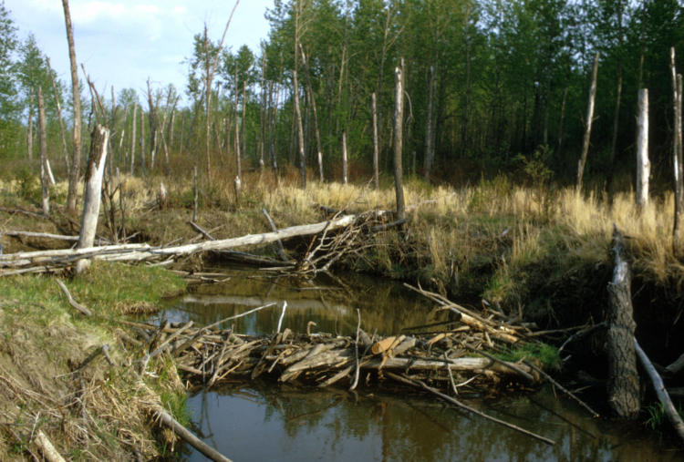
Action 2.6. Support and encourage beaver dam-building activity.
Beaver dams can help restore floodplain function, reduce sedimentation, improve water quality and fish habitat, restore wetlands, and improve habitat for many other species of birds, amphibians, and other wildlife. Beaver dams can prolong the benefits of off-channel habitats, especially during summer months. Where beavers and beaver dams are present, work with cities, municipalities, and landowners to manage their properties to benefit beaver, and reduce conflicts with people to prevent the loss of dams. Limiting development adjacent to streams and sloughs, and planting with early floodplain successional plants such as willow, can allow beavers to maintain dams and limit flooding to private property or damage to streamside agriculture. Further outreach and informational materials about the role for beaver in restoration projects may be useful for landowners, land managers, and conservation organizations. For example, see the Beaver Restoration Guidebook: Working with Beaver to Restore Streams, Wetlands, and Floodplains, a guidance document produced in collaboration by several federal agencies, including the USFWS, NOAA, USFS, and Portland State University. The ODFW also provides guidance on living with beaver.