Confluences, the point where two or more river systems come together, are ecologically vital areas, especially along the Willamette River. Over the past two centuries, the Willamette River has been transformed from complex and dynamic system, to a much more simplified and largely channelized river. Throughout the Willamette Basin, there has been widespread loss of floodplain and off-channel habitat due to human encroachment onto the floodplain, physical barriers (such as rip-rap and revetments), loss of side channels, and changes in flow regimes that eliminate floodplain-inundating flows. These changes have significantly harmed Oregon’s native species, resulting in state and federal listings of several plant and wildlife species associated with the river and its floodplain.
Protection and restoration of channel complexity, riparian habitat and floodplain forest have been identified as critical conservation needs in the Willamette Ecoregion by multiple plans and programs, including the Upper Willamette River Conservation and Recovery Plan for Chinook Salmon and Steelhead, Oregon Conservation Strategy, Willamette Subbasin Plan, and Willamette River Floodplain Restoration Study Draft Integrated Feasibility Report/Environmental Assessment.
A partnership between three grant-making organizations – Meyer Memorial Trust, Oregon Watershed Enhancement Board (OWEB), and Bonneville Power Administration (BPA) – has been instrumental in addressing the complex issues facing the Willamette River floodplain. These funders work together to support one another’s objectives, while simultaneously pursuing their own mainstem agendas.

Significant support from this partnership has enabled non-profits, watershed councils, and soil and water conservation districts to increase the extent and pace of protection and restoration efforts along the Willamette River. Other significant partners working in this area include private landowners, Oregon Department of Fish and Wildlife, Oregon State Parks, and the U.S. Army Corps of Engineers.
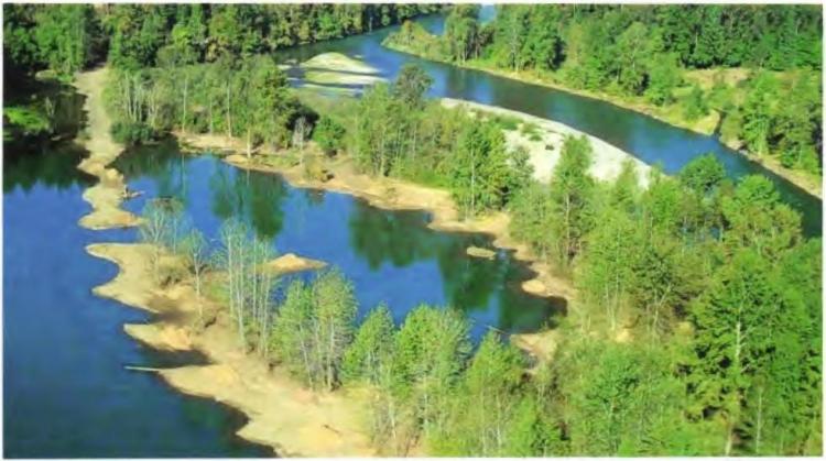
In 2010, The Nature Conservancy (TNC), with significant help from BPA and OWEB acquired the 1,271-acre Willamette Confluence Preserve. Historically, the property was used for a floodplain gravel mining operation, with extraction actively occurring from the 1950s through the 1980s. As a result, the floodplain became disconnected from the river by levees designed to protect the gravel pits. Although portions of the property were significantly altered, an intact floodplain forest remained, which is a limiting feature throughout most of the low-gradient portions of the Willamette Basin.
In 2014, TNC, with funding from the NOAA Restoration Center, OWEB (includes funding from the Pacific Coast Salmon Recovery Fund), Meyer Memorial Trust, Bonneville Environmental Foundation, and others completed an extensive restoration project to increase the amount and quality of floodplain and off-channel habitat and improve water quality. The project reconnects the Willamette River to its floodplain, creates new river channels and increases and improves shoreline habitats. A major goal of this work is to restore natural floodplain and in-channel habitat forming processes to provide critical juvenile rearing and adult holding habitat for native fish, including Chinook salmon.