Background
The droughts of the early 21st Century have heightened awareness of the issues related to water quality and quantity. Ensuring high quality water supplies is a top environmental goal for western states in the coming decades as natural resources managers grapple with the impacts of climate change.
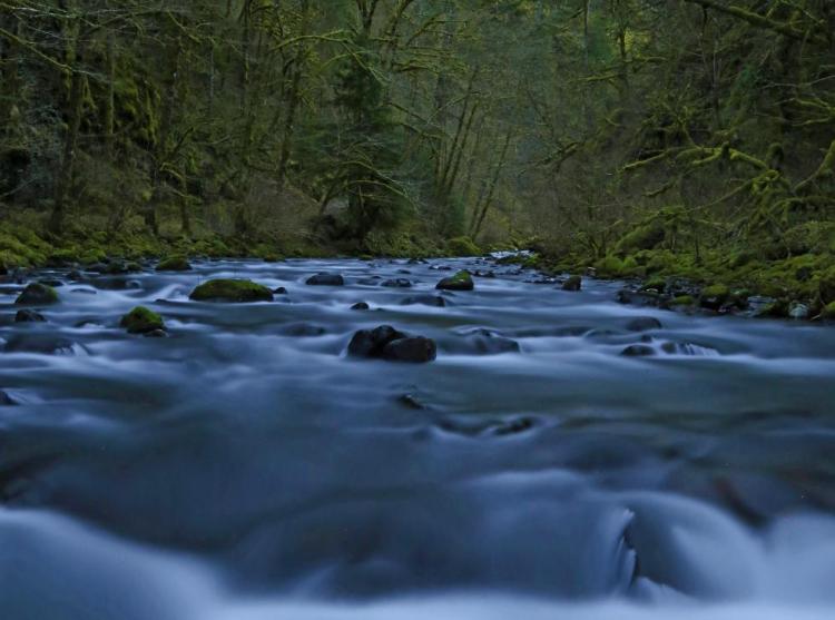
Limited water supply intensifies concerns about water quality. Low water levels could lead to warmer stream temperatures as well as increased algal growth and more frequent toxin-producing algae blooms. Variability in climate influences water quantity, and may influence water quality through increased intensity of precipitation events (National Climate Assessment Report for the Pacific Northwest, the Oregon Climate Assessment Report). Water quality is also influenced by measures taken to prevent, control, and treat pollution.
Water quality is an important issue for all Strategy Species. For example, conservation issues in the Klamath Basin Wetlands, Lake Abert, Malheur Lake, and Summer Lake place an entire network of migratory bird habitat at risk. Throughout the Pacific Northwest, watershed health is directly related to healthy populations of migratory salmon and other native fishes. In Oregon, many measures of ecosystem performance, water quality, and watershed health have been linked to native salmonid populations.
Oregon’s Integrated Water Resources Strategy
During 2009, the 75th Legislative Assembly passed House Bill 3369, directing the Oregon Water Resources Department to develop a statewide Integrated Water Resources Strategy (IWRS) to help Oregon meet its water quantity, water quality, and ecosystem needs. The strategy was to take into account upcoming pressures, such as population growth, changes in land use, and future climate conditions.
Oregon’s IWRS provides a blueprint to help the state better understand and meet its water needs, instream and out-of-stream, above ground and below ground, now and into the future. The state’s first IWRS outlines a vision, goals, objectives, and guiding principles. It identifies a number of critical issues that need to be addressed, and offers recommended actions.
The Oregon Water Resources Department (OWRD) and the ODFW work closely together to meet the goals of the IWRS. Many of the actions identified in the Conservation Strategy relate directly to actions identified in the IWRS, which are highlighted in this section. Both efforts call for actions to:
- prevent and eradicate invasive species
- protect and restore instream flows, habitat, and access for fish and wildlife
- take into account changes in land use and population growth
- address future climate conditions
Overall Goal for Water Quality and Quantity: Maintain and restore water quality and quantity to support native fish and wildlife and habitats in balance with the economic and social needs of rural and urban communities.

Water Quality
Water quality can be measured by temperature, dissolved oxygen, and turbidity (levels of fine suspended sediments and other variables). Water quality standards are set with consideration of daily cycles and seasonal precipitation events. In general, increased temperature, low dissolved oxygen, or high turbidity can indicate that water quality may be degraded. Both point and nonpoint source pollution, including toxic contaminants, bacteria, and nutrients, can degrade water quality. A major tool in identifying and prioritizing water quality problems in Oregon is the Integrated Report and list of impaired waters required under the federal Clean Water Act. This list of water bodies and stream reaches that do not meet water quality standards is updated approximately every two years. For the Conservation Strategy, the impaired waters list is used in development of Conservation Opportunity Areas to prioritize site selection and guide conservation actions.
The Oregon Water Quality Index is a method for quantifying water quality conditions throughout the state. The index considers dissolved oxygen, biological oxygen demand, pH, ammonia and nitrate nitrogen, phosphorous, total solids, and bacteria levels. A particularly useful comparative tool, the index describes water quality for various regions or reaches, and tracks trends over time. However, more information may be required to assess human health, ecological health of aquatic ecosystems, and the potential impacts of degraded water quality on fish and wildlife. Stream reach monitoring is needed to measure the current conditions for specific stream reaches. Moreover, there is a need for enhanced functional criteria to assess the success of aquatic restoration projects.
Oregon’s Existing Framework for Water Quality
State agencies that manage major water quality programs include the ODFW, DEQ, ODA, and ODF.
Oregon Department of Fish and Wildlife Programs
The ODFW’s role in vector control is to review and approve pesticides used by vector control districts or counties to protect fish, wildlife, and their habitats. State statutes ORS 452.140 and ORS 452.245 direct vector control districts and counties to obtain ODFW approval before applying pesticides to control vectors. The ODFW implements the statutes by reviewing and approving vector control plans annually, with the goal of minimizing effects on fish, wildlife, and their habitats while not significantly interfering with disease prevention and containment. The approval process is described in ODFW’s Vector Control Guidance for Sensitive Areas.
The ODFW guidance contains recommendations to avoid direct impacts of pesticide applications on fish, wildlife, or their habitats, as well as attempting to minimize indirect, chronic, and long-term impacts. The guidance focuses on:
- Promoting natural mosquito predator diversity and healthy wetlands as an important part of an Integrated Pest Management plan
- Minimizing pesticide use when there is not a current health threat
- Using larval treatments that are more mosquito-specific before applying insecticides that may impact non-target species
- Minimizing use of pesticides targeting adult insects
The ODFW’s approval only applies to defined and identified sensitive areas and species. The ODFW has identified three categories of sensitive areas for the purposes of the guidance: 1) Wildlife Areas and Refuges, 2) Wetlands of Concern, and 3) Unique, Rare, or Vulnerable Habitats. Maps of these sensitive areas are available on the ODFW website.
Oregon Department of Agriculture – Water Quality Plans and Rules
The Agricultural Water Quality Management Act was passed in 1993 and is the foundation of the ODA Agricultural Water Quality Management Program. Working with local stakeholders, the ODA completed 38 basin-specific agricultural water quality plans throughout the state to identify goals, objectives, and recommended management practices for agricultural landowners to improve water quality. The plans are updated every two years and include area-specific rules that require certain conditions to be met by law on all agricultural lands. Basin-specific plans and rules provide for tailoring to local conditions and needs. Plans and rules address controlling sources of pollution from agricultural lands, including erosion and sediment transport control, animal waste management, nutrient management, irrigation water management, and riparian area management. Plans and rules focus on outcomes, allowing landowners to choose the best practices for their operation to comply with the rules. Although compliance with the rules is required, the focus is on voluntary solutions rather than enforcement. To meet the goals of the plans, landowners typically work with local SWCDs, the Natural Resources Conservation Service (NRCS) and Farm Service Agency, and the ODA to implement a variety of conservation practices.
Oregon Department of Environmental Quality – Water Quality Programs
The Oregon DEQ is responsible for protecting the state’s surface waters and groundwater to keep them safe for a wide range of uses, such as drinking water, recreation, fish habitat, aquatic life, and irrigation. The DEQ:
- develops water quality standards
- monitors water quality
- regulates sewage, industrial discharge, and injection systems
- permits septic systems
- works with public drinking water systems
- works to control nonpoint source pollution
The DEQ develops Total Maximum Daily Loads (TMDLs) as a primary approach to address water quality impairments. A TMDL is the calculated pollutant amount that a waterbody can receive and still meet water quality standards. Per an agreement with the EPA, TMDLs are prepared by the DEQ and approved by the EPA for waterbodies in Oregon identified as water quality-limited and needing TMDLs (the 303(d) list). TMDLs are waterbody-specific and consider seasonal variation. They identify significant sources of pollution and then establish load allocations (portions of loading capacity to be allocated to existing nonpoint sources or background sources), wasteload allocations for point sources, and reserve capacity for the waterbody. Because they are waterbody-specific, TMDLs consider individual basin hydrography, climate, streamflow, dam and reservoir operations, land use and ownership, and local fish and wildlife. Successful implementation of the TMDL includes issuing discharge permits that incorporate appropriate wasteload allocations and developing and implementing nonpoint source plans as specified in the Water Quality Management Plans, Agricultural Water Quality Management Area Plans and Rules, Forest Practices Act rules, or federal Water Quality Restoration Plans. The DEQ has developed guidance for state and local government designated management agencies on developing and implementing TMDL plans within their jurisdiction.
In 2012, the DEQ began implementing a Toxics Reduction Strategy to set priorities and guide the agency’s future toxics reduction work. A high priority of the Toxics Reduction Strategy is to expand the state’s Pesticide Stewardship Partnerships Program (PSP), which identifies potential concerns and improves water quality affected by pesticide use around Oregon through voluntary actions. With support from the 2013 Oregon legislature, the expansion and enhancement of the PSP is currently underway. In 2016, there were eight partnerships in place that included monitoring, stewardship, outreach, and technical assistance, and pesticide collection events in collaboration with the ODA, other state agencies (e.g., forestry, health), and numerous local partners (e.g., OSU).

Oregon Department of Forestry – Water Quality Programs
The ODF manages state-owned forestlands in Oregon and administers the Forest Practices Act (FPA) on non-federal forestlands to ensure that water quality and resource protections are maintained during and after commercial forest operations.
Forestlands supply abundant, clean water for Oregonians. The Private Forests and State Forests divisions ensure high water quality around the state by enforcing statues and rules that protect drinking water and fish habitat from unnecessary human-caused impacts. The ODF also conducts research and monitoring to verify that current forest management practices, and any new rules or policies, maintain water quality and fish habitat.
In January 2012, the Board of Forestry (Board) directed the ODF to analyze options the Board should consider for meeting the Protecting Cold Water (PCW) criteria of the water quality standard for temperature in small and medium fish-bearing streams that flow through non-federal forest lands in the state. The objective is to establish riparian protection measures for small and medium fish‐bearing streams that maintain and promote shade conditions that ensure, to the maximum extent practicable, the achievement of the PCW criterion. The Board continues analysis and discussion of management options.
In 2013, the ODF began an annual compliance monitoring program designed to assess compliance rates across the state in a statistically valid manner. The program is designed to look at different rule sets each year on a rotating basis. The results will be integrated into an education and training program to increase awareness and compliance. In addition, ODF stewardship foresters play a significant role in implementing the voluntary conservation actions, such as those identified for the Oregon Plan for Salmon and Watersheds, which seeks to restore salmon runs to a sustainable level and improve water quality. Stewardship foresters help forest landowners identify opportunities for improving riparian function and stream habitat (e.g., large wood placement) and work with watershed councils to implement restoration projects. To date, there have been thousands of private landowner projects. Projects designed to improve stream complexity or remove artificial barriers to fish migration are the most common. Private landowners have invested nearly $100 million in non-regulatory forest practice measures across the state since 1995.
Early in 2015, the EPA and the NOAA concluded that Oregon’s coastal nonpoint pollution program was lacking additional management measures under the Coastal Zone Act Reauthorization Amendments (CZARA) to protect water quality in coastal areas of Oregon. The ODF continues to work with agency partners towards solutions.
Water Quality: Goals and Actions
Goal 1: Maintain or restore water quality in surface and groundwater to support a healthy ecosystem, support aquatic life, and provide fish and wildlife habitat.
Action 1.1. Reduce runoff from impervious surfaces.
[IWRS 6C: “Encourage low impact development practices”]
In urban areas, runoff from paved areas reduces water quality and can release contaminants into the water. Increase cooperation between governments, watershed councils, and businesses to reduce impervious surfaces and runoff to storm sewers in urban areas. Promote and permit “green infrastructure” that reduces runoff, such as disconnecting downspouts, installing green (“living”) roofs, and using permeable paving materials. Manage stormwater to minimize transfer of contaminants to streams. Restore riparian vegetation buffer strips and use native landscaping (e.g., ODFW’s Naturescaping) and bioswales to filter runoff. Continue ongoing water quality assessments and restoration programs (e.g., the City of Portland program to filter runoff via fallen leaves).

Action 1.2. Maintain and restore wetlands and riparian areas to increase filtration of sediments and contaminants and to provide shade, prevent channel erosion, and maintain stream habitat features.
[Similar IWRS action: Improve natural storage]
Wetlands often have low or no water flow, which allows sediments to fall out of the water column. Native wetland vegetation, such as cattails, rushes, and sedges, can concentrate certain contaminants in their leaves and roots, thereby removing contaminants from the water. Native riparian vegetation filters sediment before it reaches streams, provides thermal conditions that are favorable to fish and other aquatic species, and contributes large woody debris that is important for channel complexity. Restoring wetlands and riparian areas allows these natural processes to occur, maintaining habitats for terrestrial and aquatic species.
Action 1.3. Implement water quality improvement projects and management frameworks.
[Similar IWRS Action 12B: Reduce the Use of and Exposure to Toxics and Other Pollutants. IWRS Action 12C: Implement Water Quality Pollution Control Plans]
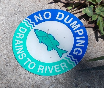
Minimize sediment delivery from land use activities that could disturb soil. Some strategies include: terracing fields, filtering run-off before it enters aquatic systems, installing sediment control basins to reduce erosion, and practicing conservation tillage. When constructing new roads, consider sediment catchment and removal in road design. Use tax credits, pollution credits, and other tools to reduce the amount of contaminants entering waterways. In urban areas, continue educational efforts, such as “Dump No Waste – Drains to Stream” postings at sewer drains. Continue implementing DEQ’s TMDL planning and ODA Water Quality Management planning, which address water quality holistically throughout watersheds, including nonpoint sources of contaminants.
Manage for water quality within an adaptive management framework that incorporates new information and responds to emerging concerns. As climate changes, weather extremes may add to the challenges that dams and reservoirs pose to native fish and wildlife species. Although reservoirs can be a helpful management response to water shortages, reservoirs can exacerbate turbidity following big storms by collecting large volumes of muddy water and slowly passing this runoff downstream, long after undammed portions of the watershed have cleared. Muddy water in winter and spring may be much more prevalent in dammed reaches compared to other portions of the individual watersheds.
Action 1.4. Monitor structural, compositional, and functional parameters of aquatic habitats for changes in water quality.
National and regional programs use water quantity and quality indicators to assess ecological function (i.e., Heinz Center, Oregon Progress Board, National Research Council). Several indicators of water quality are well developed. Use of indicators can help characterize status to better detect change and to diagnose the causes of change.

Examples of biological indicators include:
- community indices (e.g., Index of Biotic Integrity)
- species richness, number of native taxa, relative abundance of sensitive taxa, biomass, productivity
- salmonid population, structure, abundance, productivity, diversity
- species interactions, including predation, competition, presence of invasive species
Examples of physiochemical indicators include:
- water clarity
- pH
- wetland area
- temperature
- dissolved oxygen
- nutrient levels
- chlorophyll A
- total suspended solids
- presence of specific toxic contaminants
Guidelines for sampling protocols and methodology can be found through the U.S. EPA. Indices can be linked to specific stressors using a weight of evidence approach that combines existing data, literature, and scientific judgment to make predictions about ecological characteristics.
Action 1.5. Maintain and restore native vegetation throughout watersheds, prioritizing riparian corridors, floodplains, wetlands, and upland areas.
In addition to restoring riparian and wetland habitats, restoring vegetation throughout the watershed contributes to water quality by maintaining water infiltration and flow, holding soil, and preventing contaminants from entering aquatic systems.
Water Quantity
In many areas of the state, particularly during the summer, water supplies are fully allocated to meet existing uses, reducing the ability of watersheds to provide quality habitat. Water diversions are made for agriculture, municipal, industrial, domestic, and power generation uses. Other physical alterations affecting flow and habitat access include natural and artificial barriers, wetland drainage, or channelization. Timing of diversions and external factors influence disturbance regimes, sediment and bedload transport, and groundwater storage. For example, the timing and quantity of water releases from dams can have negative or positive implications for water temperature, which can impact important fish and wildlife life history events, such as the timing of salmonid migration. Global processes, including climate change, influence temperature and precipitation patterns and can potentially affect stream runoff and water supplies.
In Oregon, the OWRD is the state agency responsible for protecting instream water rights in trust to support the public interest, including uses for recreation, pollution control, navigation, and fish and wildlife habitat (Instream Water Rights Act of 1987). State agencies, including the DEQ and the Oregon Parks and Recreation Department, can apply for instream water rights for communities and to support state and federal scenic waterway designations. The ODFW applies for instream flows based on estimated monthly requirements to sustain healthy fish populations. Instream Water Right Rules (OAR 635-400) set the policy for ODFW’s instream water right applications. Instream water rights are intended to protect flows instream for aquatic and fish life, wildlife, and their habitats, recreation, and water quality. The ODFW’s policy is to apply for instream water rights on waterways of the state to conserve, maintain, and enhance aquatic and fish life for present and future generations of Oregonians. The long-term goal of this policy is to obtain an instream water right on every waterway that has value to fish and wildlife. ODFW biologists also provide advisory comments regarding impacts on fish and habitat from proposed water uses.
Water Quantity: Goals and Actions
Goal 2: Conserve, maintain, or enhance surface flows and groundwater levels that support healthy Strategy Species and Strategy Habitats. Seek opportunities to conserve, maintain, or enhance streams and lakes, as well as groundwater and spring-fed ecosystems that provide coldwater refugia for Strategy Species.
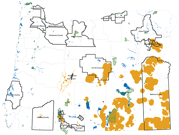
Action 2.1. Work with agencies, conservation groups, and other organizations to establish priorities, develop tools, and implement projects that maintain or restore streamflows.
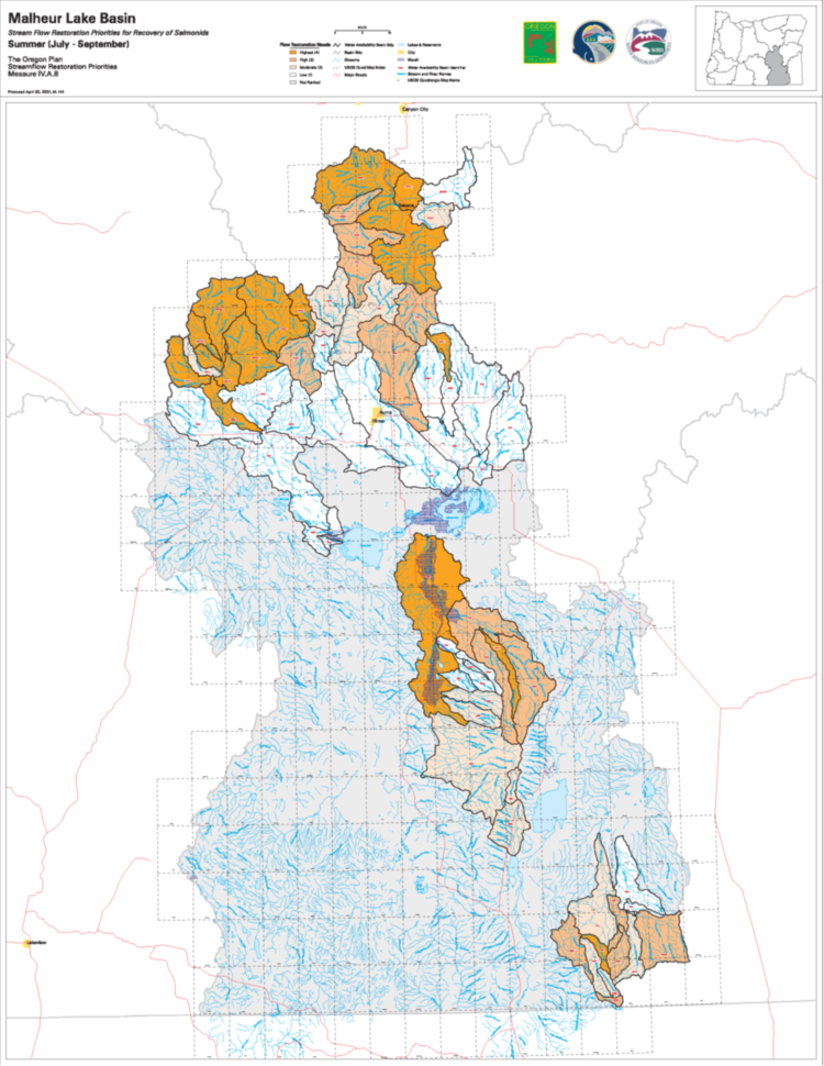
The ODFW and the Oregon Water Resources Department (OWRD) have developed stream flow restoration priority maps showing flow restoration needs and priorities. The maps display each river basin, with rankings for streamflow restoration need, feasibility for streamflow restoration, and priorities for restoration. These prioritization maps and additional information, including a summary of the prioritization process and the criteria used to establish the priorities, are available in the ODFW Data Clearinghouse, with summer priorities provided as a layer within the ODFW Compass mapping tool.
Use these priorities to implement projects that restore streamflows. Collaborate with ongoing water quantity efforts taking place under the Oregon Plan (Oregon Watershed Enhancement Board). Use voluntary conservation tools, such as the Allocation of Conserved Water Program. Purchase or lease in-stream water rights to restore streamflows [IWRS, Chapter 4]. Support local or place-based efforts that are designed to meet instream needs while also providing for growing out-of-stream demands. Some emerging examples include water markets, water banks, and incentive programs.
Action 2.2. Seek opportunities to enhance aquifer recharge and maintain groundwater.
[Similar IWRS Action 3B: Determine Needs of Groundwater‐Dependent Ecosystems]
Groundwater levels are declining in many areas. Seek opportunities to enhance aquifer recharge to restore and maintain groundwater that sustains surface flow and groundwater-dependent ecosystems. For example, restore floodplain function and restore wetlands to allow for greater water infiltration. Continue implementation of Oregon’s Groundwater Quality Protection Act, implemented by the DEQ.
Action 2.3. Use established indicators to monitor watershed function and determine thresholds for action.
Water quantity and quality need to be monitored, and watershed function and processes need to be better understood to guide restoration. Use the existing indicators for watershed health, which have been extensively studied and linked to ecological function. These indicators include:
- altered hydrology (e.g., hydrography)
- floodplain presence and connectivity
- groundwater availability
- riparian condition (e.g., width, composition, fragmentation)
- stream connectivity
- channel condition
- habitat structure (e.g., habitat types, bank erosion, channel substrate, off channel habitat, large wood).
Integrated hydrologic and water quality models simulate flow and other important characteristics. Habitat equivalency analysis and net environmental benefit analysis models use habitat characteristics to predict ecological changes that might result from proposed hydrologic alterations. Continued use of these indicators, when combined with actions to address problems with watershed function, will help to ensure that watersheds provide essential ecological services to humans, fish, and wildlife. Continue to develop methods to determine if sufficient water supplies exist to maintain ecological functions that support Strategy Species, and further identify when conservation actions may be needed.
Additional Resources
- Oregon’s first Integrated Water Resources Strategy was adopted by the Water Resources Commission in August 2012. As one of the supporting agencies and a member of the IWRS Project Team, ODFW supported the inclusion of instream needs, including water quality, water quantity, and ecosystem needs.
- The National Climate Assessment, 2014: “Changes in the timing of streamflow related to changing snowmelt have been observed and will continue, reducing the supply of water for many competing demands and causing far-reaching ecological and socioeconomic consequences. For every season, some models project decreases and some project increases (Ch. 2: Our Changing Climate, Key Message 5), yet one aspect of seasonal changes in precipitation is largely consistent across climate models: for scenarios of continued growth in global heat-trapping gas emissions, summer precipitation is projected to decrease by as much as 30 percent by the end of the century (Ch. 2: Our Changing Climate). Northwest summers are already dry and although a 10 percent reduction (the average projected change for summer) is a small amount of precipitation, unusually dry summers have many noticeable consequences, including low streamflow west of the Cascades and greater extent of wildfires throughout the region. Note that while projected temperature increases are large relative to natural variability, the relatively small projected changes in precipitation are likely to be masked by natural variability for much of the century.”
- Willamette Water 2100: “This project is evaluating how climate change, population growth, and economic growth will alter the availability and the use of water in the Willamette River Basin on a decadal to centennial timescale. The five-year project began in October 2010, and is a collaborative effort of faculty from Oregon State University, the University of Oregon, and Portland State University. It is funded by the National Science Foundation.”
- DEQ’s Water Quality Trading Program
- DSL Water Mitigation Guidance